


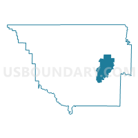
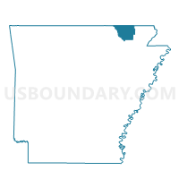
Running Lake Voting District, Randolph County, Arkansas
About
Outline

Summary
| Unique Area Identifier | 527932 |
| Name | Running Lake Voting District |
| County | Randolph County |
| State | Arkansas |
| Area (square miles) | 25.66 |
| Land Area (square miles) | 25.33 |
| Water Area (square miles) | 0.33 |
| % of Land Area | 98.72 |
| % of Water Area | 1.28 |
| Latitude of the Internal Point | 36.30803950 |
| Longtitude of the Internal Point | -90.88031040 |
Maps

Graphs
Select a template below for downloading or customizing gragh for Running Lake Voting District, Randolph County, Arkansas


Neighbors
Neighoring Voting District (by Name) Neighboring Voting District on the Map
- Columbia Voting District, Randolph County, AR
- Current River Voting District, Randolph County, AR
- Demun Voting District, Randolph County, AR
- Rickardson Voting District, Randolph County, AR
- Wiley Voting District, Randolph County, AR
Top 10 Neighboring County Subdivision (by Population) Neighboring County Subdivision on the Map
- Demun township, Randolph County, AR (8,191)
- Richardson township, Randolph County, AR (805)
- Columbia township, Randolph County, AR (662)
- Current River township, Randolph County, AR (469)
- Running Lake township, Randolph County, AR (207)
- Wiley township, Randolph County, AR (111)
Top 10 Neighboring Unified School District (by Population) Neighboring Unified School District on the Map
- Pocahontas School District, AR (10,918)
- Corning Public Schools, AR (7,141)
- Maynard School District, AR (3,084)